
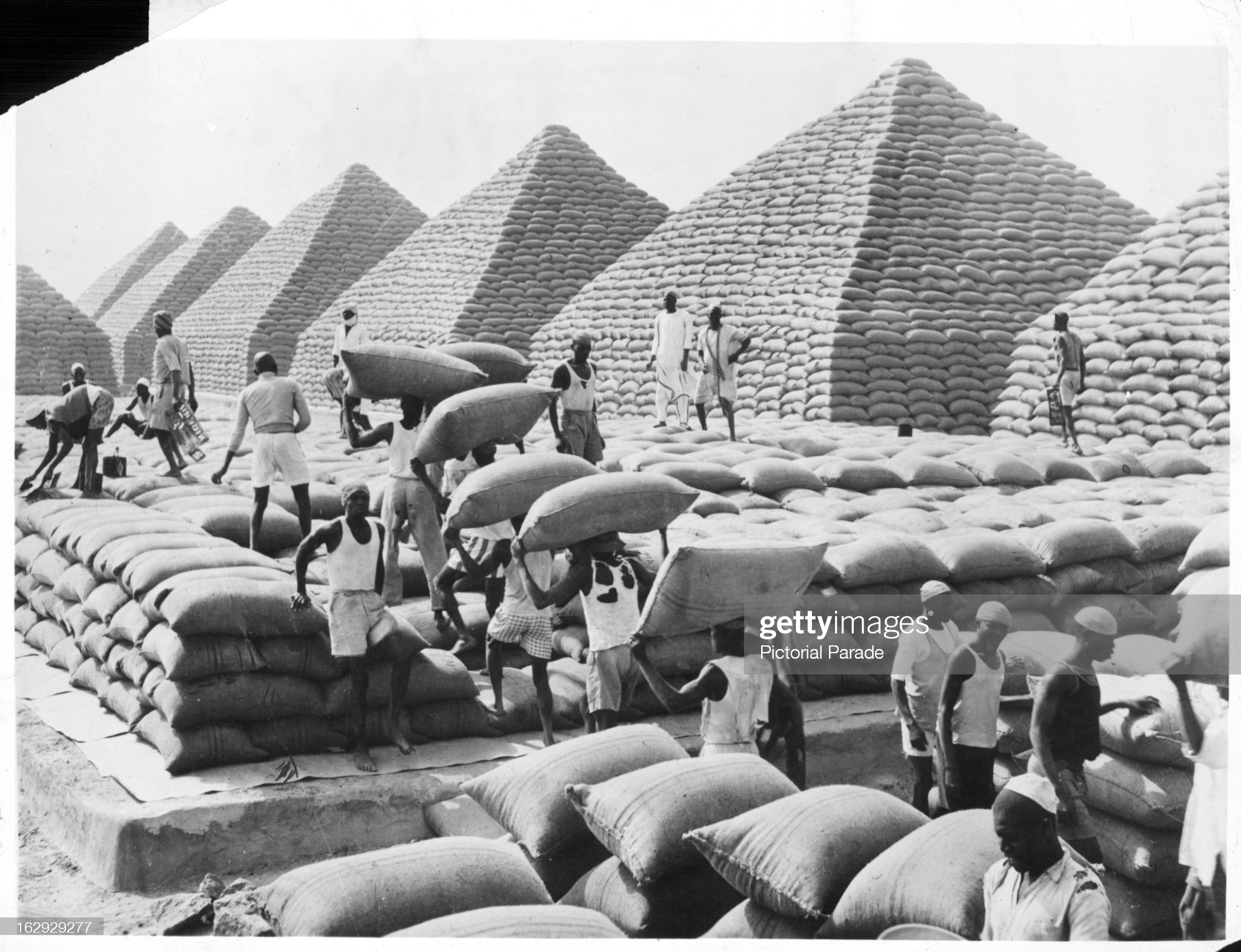
In the 19th century, African economies underwent a dramatic structural transformation. With the abolition of the slave trades that dominated commerce for the previous three centuries, commercial agriculture took off. Driving Africa’s agricultural revolution were, on the one hand, enterprising smallholder farmers and trade brokers responding to global demand for vegetable oils, cocoa, and coffee, and, on the other, European trading houses, merchants, and settlers riding the wave of economic imperialism to new markets. This project, in collaboration with Yannick Pengl at ETH-Zurich, analyzes how the confluence of these historical forces—the smallholder cash crop revolution and the spread of economic imperialism giving way to colonialism—made modern Africa.
Despite a prominent earlier scholarship in the 1960s and 1970s by the likes of William Hance, Polly Hill, Walter Rodney and A.G. Hopkins on the cash crop revolution and its consequences, few studies systematically build on their contributions. Too often the starting point for much analysis on colonialism remains the Scramble for Africa and the Berlin Conference of 1884-1885—with a disproportionate focus on Europe’s imperialists. Such an approach fails to account for the endogeneity of colonialism—that is, the underlying causal factors that explain variation in colonial state-building and economic extraction. One of the core contributions of our project is to demonstrate how the continental distribution of factor endowments for cash crop agriculture shaped the geography of colonialism with important economic, social and political consequences. Moreover, in many studies of colonialism, agency tends to reside only with Europe’s empire-builders—and not with Africans. The history of Africa belies such an approach. Instead, as we show, the making of modern Africa arose out of the strategic interactions between and within these disparate social forces—with the latter representing millions of farmers, migrants and traders embracing cash crop agriculture while navigating the tightening constraints arising from colonial extractive institutions built to advance the interests of various—and at times competing—constituents of the European imperial regime.
To fill this gap in the literature, over the course of the past five years, supported by a U.S. National Science Foundation award and funding by the Swiss National Science Foundation, we have built a comprehensive dataset of historical African economic geography, including detailed geospatial information on sites of cash crop production and mining at the end of colonialism across most states in Sub-Saharan Africa. We draw on two sources of data. We collected administrative data from colonial records and other historical sources on the volume and value of the most important agricultural commodities and minerals produced by each state (i.e., those that make up at least 10 percent of total exports at the end of colonialism) standardized in 1960 US$ and aggregated at the second-administrative level. In the course of this research, we discovered a historical map depicting the source location of more than 95 percent of all exports across 38 African states, standardized in 1957 U.S. dollars ($). Constructed by a team led by the aforementioned William Hance, a renowned geographer of Africa, the map draws on “hundreds of sources…including maps, articles, agricultural yearbooks, reports of commodity boards, and product and regional studies.” As far as we know, the Hance dataset is the most exhaustive and granular representation of the spatial diffusion of the cash crop revolution across Africa, but has never been systematically analyzed until now.
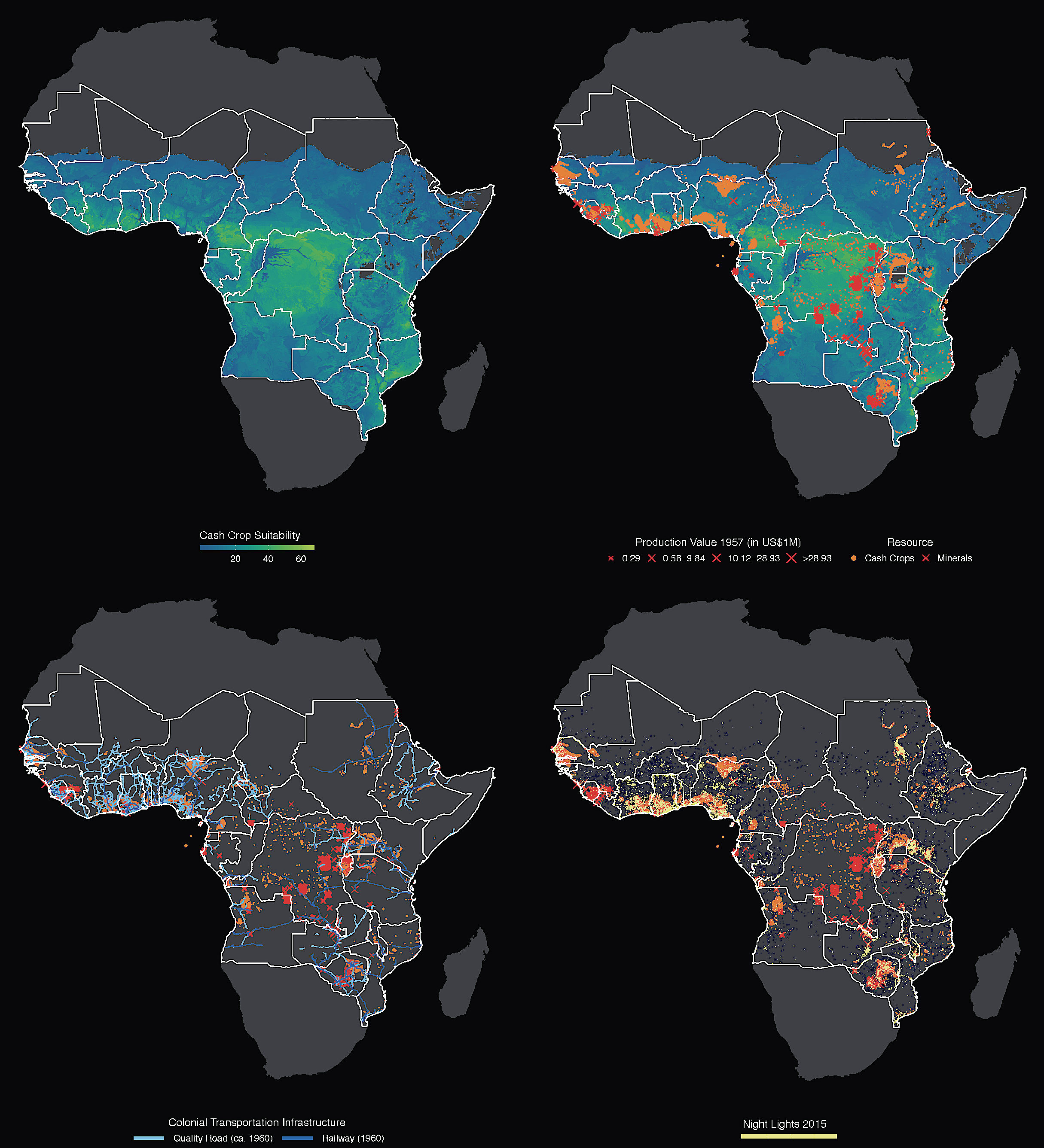
This figure illustrates the core of our central argument on the confluence of cash crop agriculture and economic imperialism on Africa’s long-run development. The upper-left panel illustrates cash crop suitability (blue, less suitable areas, to green, more suitable areas). The upper-right panel illustrates how cash crop suitability shaped cash crop production (orange dots). Each orange point represents US $289,270 export value of cash crop production in 1957. Red Xs represent mining sites producing varying export volumes. In turn, the lower-left panel shows the link between colonial resource extraction and colonial infrastructure investments (roads in light-blue and railways in dark-blue). Finally, the lower-right panel overlays the colonial resource data with luminosity at night in 2015 (measured by satellite night-time lights in yellow) as a proxy for economic activity, and which indicates the spatial inequality entrenched by colonial resource extraction.
Armed with this incredible data, our analysis illustrates the extent to which the cash crop revolution shaped colonial economic geography. Colonial extraction did not merely leave a legacy of differential development, however. We further show—leveraging statistical analysis that enables us to estimate the spillover effects of colonial cash crop production—that the agglomerating effects arising from colonial extraction came at the expense of surrounding areas, which ended up significantly worse off than otherwise would be expected based on their underlying characteristics. (See here for a summary of our argument written up for VoxEU.)
Yannick and I are synthesizing our findings in a book, tentatively titled, Markets, States and Power: The Cash Crop Revolution, Colonialism and the Making of Modern Africa. (See here for the book proposal.) The book offers a systematic and integrated analysis of this critical transformation. We think the book will have broad appeal to those interested in the region or to big debates in economic development, ethnic politics, and gender relations. Beyond chapters on the origins of spatial inequality, ethnic politicization and powersharing, we are also testing the argument Ester Boserup advanced in her classic work that conceived of sub-Saharan Africa as historically the “region of female farming par excellence” (due to the absence of the plough and women’s contributions in food agriculture), but which was then upended by the gendered nature of colonial cash crop extension services. Boserup’s sweeping thesis has been much debated and discussed but never systematically tested. In the penultimate chapter we analyze the degree to which contemporary countervailing forces—democratization, agricultural liberalization, and Chinese-backed infrastructure projects, but also worsening climate change—are remaking Africa and disrupting the spatial equilibria borne out of Africa’s colonial cash crop revolution.
